Photo of a Snowy Owl in Oregon

Snowy Owl
Snowy Owl near Burns, Harney County, Oregon 18 Dec 2011


12/18/2011

“What do you think?” said Marvin, “The newspaper reported a Snowy Owl has been sighted near Burns. Maybe we can catch a photo of a bird rarely seen in Oregon.”

“It is the middle of December,” I replied, “and typically really, really cold in the high desert… It’s 334 miles from here to Burns… a long drive in winter conditions… through the Cascade mountains… snow on the ground… ice on the roads… but traffic cams show roads clear of snow… It’s a pretty crazy thing for a couple of old codgers from the valley to do… Let’s go for it. We have a reputation to uphold.”  

“That owl will draw a lot of attention from bird watchers… we may need reservations to stay in Burns…  Be sure to bring your arctic parka and mittens… maybe a pair of long-johns.”

Marvin secured reservations at our favorite motel in Burns… we loaded our gear into my 4WD Blazer and headed for Harney County. As reported the highway was clear of ice and snow so we enjoyed a scenic drive across the state of Oregon… mid-winter… didn’t need to use tire chains.

“The paper said the owl was seen at milepost six on highway 78 south of Burns… that’s been over a week ago… do you suppose the owl will still be there?”

“Let’s drive out to mile post six and look… we don’t have better information. If it is not there we can go to plan B.”

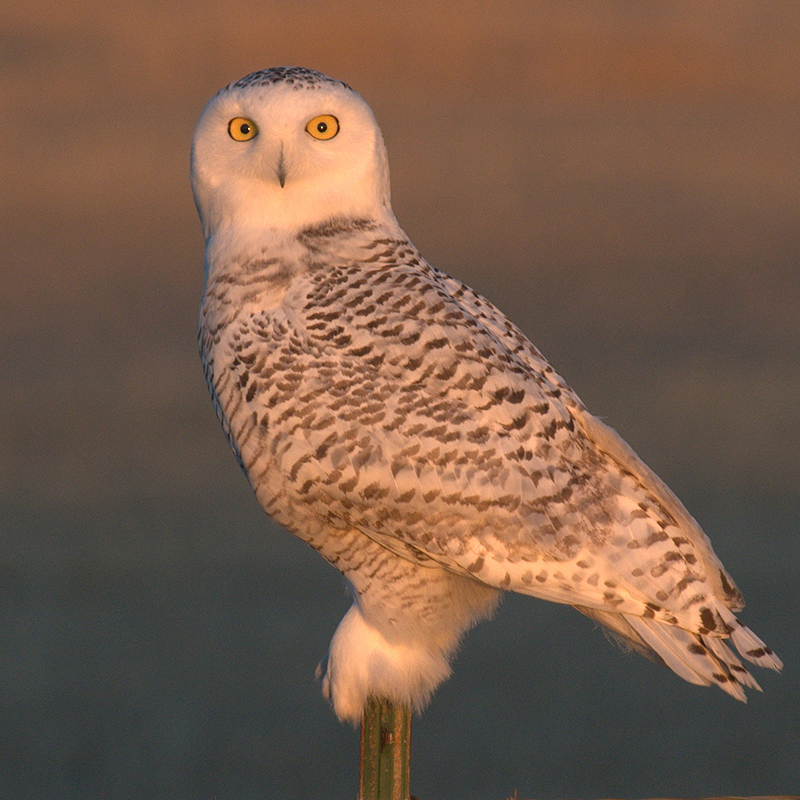
Sure enough… milepost six… perched on a fence-post next to the road… oblivious to traffic on the highway and cars stopping to park roadside… ignoring camera-toting birdwatchers striving for a better close-up shot… sat a Snowy Owl… apparently reveling in the attention it was receiving.

We exhausted the sweet light of sunset, collecting great shots of the Snowy owl… perched like a statue on a fence-post.

We came back the next morning and exhausted the sweet light of sunrise… we collected more great shots of the Snowy owl… perched like a statue on a fence-post.

 The owl occasionally shifted its feet and occasionally swiveled its head to look around but otherwise there wasn’t much action.

“What is our plan B?” said Marvin, “Maybe…”

“Good idea.” I said, starting the engine of the car. “We can head over to the Malheur Refuge and check the action there. We might see something interesting.”

story and photo byLarry

Print Friendly, PDF & Email

Related Images:

Put Palouse Falls on your Bucket List

Paloose Falls
Marvin at Palouse Falls

6/22/2012

“I would like to see Palouse Falls someday,” said Marvin, “It’s on my bucket list.”

We were planning field trips for the summer. It’s unusual for Marvin to make a request so I was taking his suggestion seriously. Usually he is content with letting me decide where we go.

“Tell me why you want to go there.”

“It’s the official State Waterfall for Washington… The falls are about 200 feet high… that’s seventeen feet higher than Niagara Falls… It’s geologically significant… the result of Missoula Floods… the Palouse river used to be tributary to the Columbia but now it’s tributary to the Snake River…  I’d like to take a few pictures.”

“You have done the research. Pack your camera gear and let’s go… are you going to bring your kayak? I’ll take your picture if you run the falls.”

“Nope… Tyler Bradt has already made that plunge and set the record… being second spoils the appeal for me… but it would be quite a ride.”

“The falls change height depending on the water flow… as much as 12 feet… so maybe you could pick a day when there is more water and reset the world record.”

“Rafa Ortiz tried that too… but he was disqualified because he didn’t stay in his kayak during the free fall portion. He didn’t try again… once was enough.”

“Two tries and both lived to tell about it… that’s pretty good odds…”

“It helps to be young and skinny… no one will accuse either of us of that.”

“Do you know what “Palouse” means?”

“It’s what people now call the Native Americans that lived near there… In their journal Lewis and Clark called them ‘Pellotepellows’…  they were related to the Nez Perce and raised horses referred to as ‘a Palouse horse’… now Appaloosa.”

“Those are beautiful horses… We should go horseback riding while we are there…”

“I’ll take your picture if you ride one… bareback.”

Watch Tyler Bradt do the plunge: https://www.youtube.com/watch?v=hyb3As78YfM

Story and photo byLarry

Print Friendly, PDF & Email

Related Images:

The Geographical Center of Oregon

Post, Oregon
Post Oregon store photo by Jan Jackson

“Have you been to the geographical center of Oregon?”

Marvin’s question seemed innocently proposed but I knew better… he likes to use leading questions to start a conversation and it is likely that he already knows the answer. We were in Central Oregon, defined by three counties, Jefferson, Crook and Deschutes. We had passed through Jefferson County and now we were in Crook County, east of Prineville and headed toward Post and Paulina on SH 380. I suspected his question involved one those two communities so I decided to be indirect and answer with a question.

“I wonder how they calculate the center of a state… Oregon’s almost square so it would be easy to get a rough estimate by marking diagonals and see where they cross.”

“When I did that the diagonals crossed pretty close to Post,” replied Marvin.

In the past I did some computer based research. A U.S. Coast and Geodetic Survey (USCGS) put the center of Oregon about 16 miles south of Post, but not near any community. Although, in remote Oregon 16 miles is considered nearby… some ranches out there are bigger than that.

A Center of Gravity method put the center south of highway 20 in Deschutes County, a few miles from Millican, about 30 miles SW of Post, but Oscar Adams, the senior mathematician for USCGS, ridiculed the question and said there is no such thing as a geographical center of any state, country or continent. He claimed there was no exactitude in any of the methods used. “Make your own definition of center,” he said, “one is as good as another.”

Methinks he doth protest too much. He had a reputation for accuracy to uphold and he probably was embarrassed by telling people he couldn’t provide an exact answer.

I tried a more modern solution in reverse… I used Google Earth and put the center cross-hairs smack dab on Post, then zoomed out until I had the boundaries of Oregon on screen. With a little fudging  Post looked pretty good for the center of the state. Then I did a Google map search for “Oregon” and looked at the icon’s location… it’s a few miles east of Brothers, Deschutes County, about 25 miles south of Post, but still in Central Oregon.

Alfred Korzybski’s famous statement: “the map is not the territory” holds true… it is impossible to map a three-dimensional sphere onto two-dimensional paper without creating some area distortions, thus no exact center is possible. The map is the problem.

“Marvin, I’m hungry. Are you ready for lunch? I hear the store in Post makes an excellent meatloaf sandwich and I want one of those t-shirts that claim Post is the geographical center of Oregon.”

For more traveling Oregon stories: http://www.countrytraveleronline.com/

byLarry

Print Friendly, PDF & Email

Related Images:

The Huge Tamarack Tree

26 August 2013: “Ralph, I know where there is a huge Tamarack tree.”

Ralph and I were talking about big trees and I knew at the mention of one he hadn’t seen he would be ready to travel so I dropped the hat.

“Let’s go give it a look.”

My son, Chris; Lucy, the dog; Ralph, the tree guy; and me, the camera guy… loaded our gear into my Chevy Blazer and we were off to Eastern Oregon’s Strawberry Mountain Wilderness Area to measure and photograph what I hoped would be the largest Tamarack tree in Oregon, perhaps it could even be the national champion.

Western Larch
Chris, Lucy, Ralph and a huge Western Larch

I saw the tree while looking for butterflies during a field trip and marveled at its size. It was the biggest Tamarack I had ever seen. Now we were going to see if it measured up, officially. Ralph was the certification expert. He called the tree a Western Larch… and I discovered “Tamarack” is the common name for the Eastern Larch.

Somehow the “Tamarack” name had also been given to the Western Larch. “Tamarack” made sense to me because to me they looked very much alike… same genus… but different species… and different scientific names. A botanist would reference the Western Larch in writing as “Larix occidentalis” and the Eastern Larch as “Larix laricina.” To be technically correct the authority’s name would be appended after the genus and species but not italicized… technically correct is mainly used in botanical journals but purists will also append authority names.

Unfortunately, my tree wasn’t big enough to be crowned the new champion. In Ralph’s words: “We saw the tree, and it was a marvel to behold, but a champion to dethrone another it was not.”

How big is the champion? According to Wikipedia the national champ is 153 feet tall and 22 feet around (seven feet diameter). It can be found near Seeley Lake, Montana. Locals refer to the tree as “Gus.”

Oregon’s record, located in the Eagle Cap Wilderness, measured as 103 feet tall, 22 feet circumference (seven feet diameter). (Information quoted from the Oregon Encyclopedia)

 How big was mine? 120 feet tall and 13.5 feet circumference (four feet, three and a half inches diameter). My tree was taller but not big enough in circumference to surpass the Oregon champion. I would have to settle for the biggest Western Larch I have ever seen.

byLarry

Print Friendly, PDF & Email

Related Images:

The Trees on Wizard Island

Wizard Island, Crater Lake
Wizard Island, Crater Lake National Park

July 16, 2014: “I want to spend some time looking at the trees on Wizard Island,” said Ralph, “and there are two record trees in the Park that were originally measured during the 1940’s that need to be remeasured and certified. With luck we can do both.”

Ralph brought a tent. We both brought a sleeping bag. We were prepared to camp out.

Did we have reservations?

It did not occur to us we would need reservations. We were surprised to find an overflow crowd at Crater Lake. Not only were no camping sites available but the Wizard Island tour would be space available.

The reservation system was down… crashed… so we had no idea how many people would show up for the tour. Nor could we risk staying on the island and taking the next boat back to shore. The next boat might be full… all the next boats might be full. We elected to look for the two “lost” trees and skip the time-limited island tour.

We had “approximate” locations for the two trees. The Park Historian was some help… he had also looked for the trees but was unable to locate them. His trials eliminated some possibilities for us though.

Larry and record tree
Big tree at Crater Lake Larry Rea

One of the trees was next to the road and we found it quickly, before evening set in we had measurements and photos.

We had to leave the park and find a campsite somewhere in the adjacent National Forest. We were lucky to find an abandoned hunter’s camp where we set up the tent and spent the night without noisy neighbors. The noisy mosquitoes were another unanticipated problem. Eventually sleep prevailed.

The next morning, we looked for the other tree. We estimated the other tree was about two miles off road, downhill, and near where a couple small streams came together. I plotted coordinates to use with my GPS and we began the search.

Fortunately, an abandoned power line gave us a good trail to follow and walking was easy… downhill. When we passed two and a half miles we turned around and worked our way back. Ralph spotted a couple trees he wanted to measure but I was quickly running out of steam going uphill. The combination of elevation, sunshine and uphill was turning hiking into hard work. The two and a half miles down was more like ten miles going uphill.

I elected to take a rest stop while Ralph investigated trees. While he was gone I decided it would be a good idea to continue, slowly, and let Ralph catch up to me. That strategy would reduce the time spent on the return trip and my rest stops wouldn’t be an issue.

When Ralph returned to the trail he wasn’t sure he was below the location where we parted. I could be waiting down the trail.  So, he backtracked until he was sure he was below where we parted and then hiked back up the hill to find me. By then I had decided to return to the car.

Ralph was worried about having missed me on the trail. He thought I intended to wait for his return. I worried about him… he had the keys to the car. When we got back together at the car we reviewed our hiking strategy to make sure we both understood what the other was planning to do.

I love when a plan comes together.

byLarry

Print Friendly, PDF & Email

Related Images: